On a computer, right-click a corner, choose Measure distance, click the other corners, then click your first point, and the card shows Total area in ft² and m². A check on Nov 4, 2026 showed that readout, though Google's help page still describes distance only. How to measure square footage on Google Maps changes on the Android and iPhone apps. Area there was not checked, so you multiply two sides in feet.
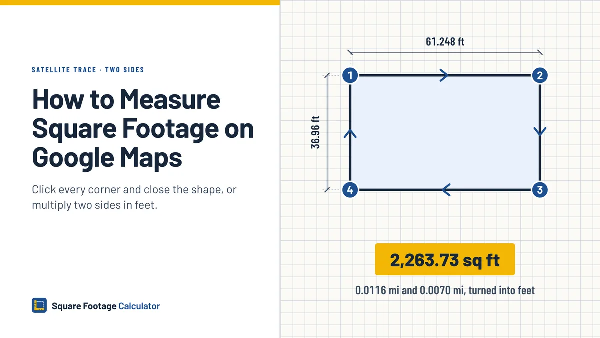
Table of Contents
- How to measure square footage on Google Maps
- Measure two sides in the Android or iPhone app
- Which other Google tools show area
- Trace the outline in Google Earth
- Close a shape in Google My Maps
- Google Maps square footage of a house
- How accurate is a satellite square footage estimate
- Google Maps measuring mistakes and fixes
- FAQ
- Conclusion
How to measure square footage on Google Maps
Switch to the satellite layer and zoom in until the corners look sharp. Then trace the outline and read the area off the card.
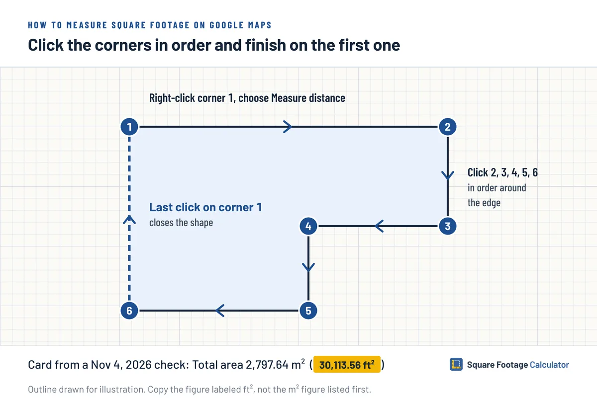
- Right-click the first corner and choose Measure distance.
- Click each of the other corners in turn. Missed one? Drag the point onto it.
- Finish by clicking the first point again, which closes the outline.
- Read Total area on the card at the bottom of the screen, just above Total distance.
The Nov 4 check ran in desktop Chrome on a Mac, in a US view. The card read "Total area: 2,797.64 m² (30,113.56 ft²)" and "Total distance: 244.56 m (802.37 ft)". Copy the ft² figure, and check the unit labels on your own screen first.
That is one reading, and the Google Maps help page on measuring still lists only distance, in miles and kilometers. If no Total area line appears for you, measure two sides and put them in the square footage calculator.
Measure distance won't work in Lite mode, which shows a lightning bolt at the bottom of the map.
Measure two sides in the Android or iPhone app
Multiply two sides yourself in the app. Area in the app was not checked, and Google's app help describes distance only, which does not prove the app can't show area.
Steps in the app
- Touch and hold the first corner until a red pin drops. Pick a spot clear of place labels and icons.
- Choose Measure distance.
- Pan the map until the black circle sits on the next corner, then tap Add point.
- Read the length at the bottom of the screen and write it down.
- Undo drops the last point. More, then Clear, drops every point, so you can repeat for the short side.
Turn the readings into square feet
Change each side to feet before you multiply anything. One mile is 5,280 feet, and one kilometer is 1,000 meters. If your screen already gives feet, as the computer card did on Nov 4, skip the first two rows below.
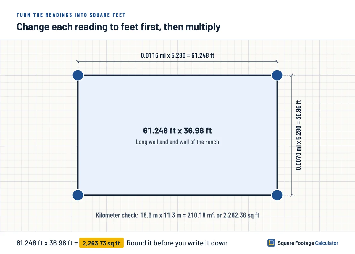
Say the long wall of a one-story ranch reads 0.0116 mi and the end wall reads 0.0070 mi. Both are made up for the arithmetic.
| Step | Math | Result |
|---|---|---|
| Long side | 0.0116 x 5,280 | 61.248 ft |
| Short side | 0.0070 x 5,280 | 36.96 ft |
| Area | 61.248 x 36.96 | 2,263.73 sq ft |
The kilometer total catches a conversion slip, though it comes from the same clicks, so it cannot catch a bad trace. Readings of 0.0186 km and 0.0113 km mean 18.6 m and 11.3 m, which multiply to 210.18 m². Run that through the square meters to square feet conversion and you land on 2,262.36 sq ft, under 2 sq ft away from the mile answer.
If a reading is rounded to 0.0001 mi, each step of the last digit is 0.528 ft, so the decimals in 2,263.73 sq ft are not real precision. Round the area before you write it down.
Two sides only suit a box, since a box around an L-shaped house picks up the empty corner of the L. On a phone, split an odd footprint into boxes and total them.
Which other Google tools show area
Google Earth and Google My Maps report area once you close a shape, and Google Earth Pro has a Polygon tab for it. You don't need them for area on a computer, going by the Nov 4 check. They help when you want a method Google's help documents, or a closed shape on a phone.
| Tool | Runs on | How area shows | Good for |
|---|---|---|---|
| Google Maps | Computer | Total area on the card, seen in the Nov 4 check | Any outline you can click around |
| Google Maps app | Android, iPhone | Help covers distance only | Two sides of a box shape |
| Google My Maps | Computer steps in the help | In blue, once the shape closes | A computer method Google documents |
| Google Earth | Browser, Android, iPhone | With the perimeter | A closed shape on a phone |
| Google Earth Pro | Windows or Mac program | On the Polygon tab | A shape you want to save |
Trace the outline in Google Earth
You can also measure square feet on Google Earth, and Google's help spells out the steps. You click every corner, join the last click to the first, and Earth reports the area.
In a browser
Search for the address and click Measure on the left, and Earth turns the view to look straight down. Click around the outline, finish on your first point, and read the area and perimeter on the right.
In the phone app
Tap Measure, pan to a corner and tap Add point, then work around the building. Back at the starting corner, tap Close Shape to see the area.
In Earth Pro on a desktop
Open Tools, then Ruler, select Mouse Navigation at the bottom left, and choose the Polygon tab, which measures a shape on the ground. Click the corners and read the area in the Ruler window. Save keeps the shape for later. Feet or meters is a setting in Tools, Options on Windows, or in Google Earth, Preferences on a Mac.
Close a shape in Google My Maps
My Maps draws an area on the familiar Google map too, and Google's steps for it are written for a computer.
- Sign in to My Maps and open a map, or start a new one.
- Click Measure distances and areas.
- Click each corner. Finish with a double-click, or by clicking an earlier point so the shape closes.
The distance, and the area once the shape is closed, appear in blue. The My Maps help ties the units to your scale and country, so look at the label before you copy the figure.
Google Maps square footage of a house
From above you trace the roof edge, not the walls. Eaves hang out past the siding, so a traced house with eaves comes out larger than the ground it stands on.
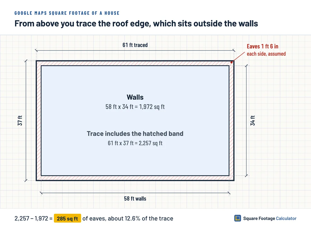
Round the ranch to 61 by 37 feet and the trace is 2,257 sq ft. Now assume, for the math only, that the eaves stick out 1 ft 6 in on every side. Take 3 ft off each dimension and the walls enclose 58 by 34 feet, which is 1,972 sq ft. The roof outline is 285 sq ft bigger, about 12.6% of the traced figure.
A second floor never shows from the air, so use a tape and a floor-by-floor sketch of the house when the size has to be right. The trace is flat as well, and a sloped roof covers more surface than its outline, so add the roof pitch to that outline before you order roofing.
How accurate is a satellite square footage estimate
Treat a satellite trace as a planning figure. One check shows the Total area line exists, not that its figure is right. Google's Maps help gives no accuracy number, and for Earth Google calls every measurement an estimate and says it is no substitute for an onsite or survey-grade one.
The Google Earth measuring docs say lengths and areas skip any change in elevation, and that results come out best from a top-down view on the satellite basemap. The Earth help adds that errors are more likely around 3D terrain and buildings.
Check how old the photo is. In Google Earth, hover over the map and the capture date shows in the status bar along the bottom, though not in every place or at every zoom. A deck or garage built after that date is missing from your trace.
For land, your county's parcel viewer may have a measure tool of its own. The Maricopa County Assessor's Measure tool reports the length or area of a shape in units you choose. Because Google calls Earth's figures estimates, hold your trace up against the lot size on the county record before you rely on it.
Google Maps measuring mistakes and fixes
Check your figure against these slips. The numbers come from the ranch readings and the Nov 4 card.
| Slip | What you see | Fix |
|---|---|---|
| Multiplying miles before converting | 0.0116 x 0.0070 gives 0.0000812 sq mi | Turn each side into feet first |
| Reading square meters as square feet | The Nov 4 card lists 2,797.64 m² ahead of 30,113.56 ft² | Copy the figure labeled ft² |
| Leaving the shape open | No area to read | Click the first point or tap Close Shape |
| Calling the roof trace the house size | 2,257 sq ft instead of 1,972 | Take the overhang off every side |
| Tracing in a tilted 3D view | Corners land off the walls | Trace from straight overhead |
| Tracing through trees | Part of the roof edge is hidden | Tape that stretch from the ground |
FAQ
Can Google Maps calculate square footage?
Yes on a computer, going by a check on Nov 4, 2026. Close a shape in Measure distance and the card shows Total area in m² and ft². Google's help page still describes distance only, and area in the Android or iPhone app was not checked.
Can you measure a room on Google Maps?
No. The satellite photo shows a roof, and nothing on it tells you where the bedroom walls stand. Measure a room from inside with a tape, or try phone measuring apps for a rough number you check by hand.
Does Google Earth show square feet?
Google Earth shows area in whatever unit is selected, so read the label next to the number. Change it with the dropdown beside the measurement, or set a default in the Format and Units part of Settings. In Google Earth Pro, you choose feet or meters in the settings.
Can the Google Maps app measure square footage?
Area in the app was not checked, and Google's help for Android and iPhone describes distance only. To measure square feet on Google Maps from a phone, take two readings and multiply them in feet. For an outline with more corners, the Google Earth app can close the shape and show its area.
Does Google Maps show a lot's square footage?
On a computer it can, going by one check on a closed shape. Click the lot's corners in Measure distance, finish on the first point and read Total area. Treat that as a planning figure, and set it beside the county's number for that parcel before you rely on it.
Conclusion
Once the card shows Total area, ask what that number will be used for. A rough plan can live with the outline. The ranch dropped 285 sq ft between roof edge and walls on assumed eaves, so anything you pay for or sign needs a tape on the walls first. A basement stays hidden from the air too, so settle whether it counts toward the home's total before you quote a size.